Didda Hjartardottir
“Snippet”
Staðsetning / Location:
The Artwork “Snippet” is part of a project on maps
that has earlier seen two other works. The map project is based on the London
A-Z.
The first? How ,Why, When? 2003. A series of three oil paintings based on a
small area of the
London A-Z , close to where I live.
Using the prime colours,
each painting has one of these as it?s
main colour so you have a yellow, blue and red
painting.
My second take on maps ?Box
maps? The same details are blown up further and jigsaw puzzles are pasted on
the inside or outside of three cardboard boxes. The puzzles giving colour and shape to the maps. This is where the
two-dimensional map takes on a three-dimensional quality.
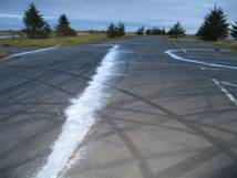
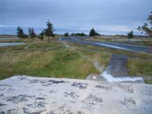
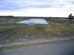
The third .The one I have made for Project Patterson “Snippet”
2006. A tiny bit of the street area around Highbury
Corner is blown up to full size 1:1. What can be seen on this little bit of
map, is letters that spell Highbury and underneath
it Isl. A few lines that indicate parts
of symbols for the overground as well as the
underground stations and
a star, symbol for the Post office. The whole area is shaped as
an irregular elongated triangle
Of Exactitude in Science
.. . . In that Empire, the craft of Cartography
attained such Perfection that the Map of a Single province covered the space of
an entire City, and the Map of the Empire itself an entire Province.
In the course of Time, these Extensive maps were found
somehow wanting, and so the
it
to the Rigors of sun and Rain. In the western Deserts, tattered Fragments of
the Map are still to be found, sheltering an occasional Beast or beggar; in the
whole Nation, no other relic is left of the Discipline of Geography.
>From Travels of Praiseworthy Men
(1658) by J. A. Suarez Miranda
>From A
Universal History of Infamy (1972) by Jorge Luis Borges
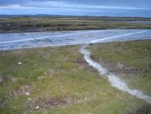
The idea is to unite two different areas.
A small piece of street area as depicted in the London
A-Z invades Icelandic ground, conversely a small area of ground in Iceland
shapes a
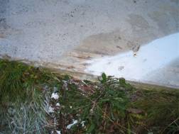
London Street map The ground causes
flat even streets to land in a ditch and roll over the foundations of
houses and roads in a haphazard way. The map that is man?s attempt to move the physical reality of his
surroundings onto a piece of paper. The map interprets big areas and omits as
much as it exaggerates .The ground gives to the flat paper that represents a
street map a physical reality, a new body. While a battle is
fought between the map and the earth, the mind and the body. They take
on each others image.
The possibility to locate the work in
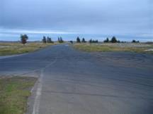
Dimension. A year ago I came to a deserted
A short while later
The deserted streets surround the houses with lines
painted on them for guidance and empty car parking spaces. A few windswept fir trees
grow here and there and seem to hang around as though inhabitants lost in
thought over whether to leave the place or whether to stay.
Few places could be more symbolic for the departure of
the American base from Icelandic ground than what is left of
The making of the Artwork
The directions of the map coincide with those of
I work like a blind person.
At the beginning, I have difficulty connecting with
the work as I am unable to step back a few meters to get an overview.
All I see is lines.
The size of the letters surprises me and causes me to
wander whether the work is somehow an expression of megalomania.
But almost immediately I experience the work as an
opposite, I am the ant tiny and powerless in the expanse of the earth.
Everything keeps shifting and I don’t know which side
I am on.
Am
I Gulliver in the land of the Lillitputs or Gulliver
in the Land of
Giants.
As time goes by, I form a closer connection to the
work. It is funny to be able to make a six meter mistake.
When it comes to the letter b I enjoy feeling a
resonance with the making of the Box maps. As it covers
ditches and uneven surfaces. Finally while making the letter s I
experience joy when trying to connect the upper and the lower hook of the
letter in a convincing way. I discover the best way to do this is by running
the distance between the two. Thereby using the whole body as a replacement for
the hand to
make the swoop.
It is a strange feeling to have completed the work and
yet not seen it as a whole.
The weather has a great impact when one is working
outdoors and I find out as the days pass that
The future is bright.